


Here are some of the walks and off road bike rides that I've
enjoyed. The map is indicative only - don't use it for
navigation...
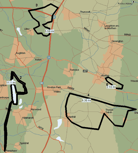
...unless you know the area well. Otherwise all of these
ride/walks need decent maps and of
course you can accurately customise your own routes.
Trips....
- Rother Valley Country Park and the Transpennine
Trail (Ireland to Greece via Rotherham!)
- 13 mile mountain bike ride (100%
off-road)
- 6 mile walk/mountain bike ride (50% off-road)
Ulley - Morthen
- 10 mile walk (40% off road) - Kiveton Park
Station-Chesterfield Canal towpath-Turnerwood-Thorpe
Salvin-Harthill
- 3 mile walk (100% off road) - Anston
Stones
- 14 mile '3 churches' walk - Laughton en le
Morthen
- 6 mile Laugton en le Morthen - Roche Abbey circular
1. The Rother Valley Country Park and the
Transpennine Trail
The country park is a reclaimed opencast mine 0.5 miles west of
Kiveton/Wales and south of Aston cum Aughton. It consists of 2 sets
of lakes. One set is a nature reserve, and the other is one of the
local sports playgrounds with water skiing, jet skis, dinghy
sailing, coarse fishing, golf course, kids playground, etc. The
main lakes are also surrounded by a 3 mile perimeter track that
makes a great training circuit for joggers and cyclists.
On the west side of the lakes is a disused railway track with a
cycle, horse riding, and walking track. If you do this route you're
on euro long distance route E8 or...
The transpennine trail
Euro long distance path E8 runs from the west coast of Ireland
to Istanbul in Turkey. The 180 mile/300 km English section runs
from Hull to Liverpool, passing near to Sheffield/Rotherham before
going over the pennines and skirting Manchester on its way to
Liverpool.

After which you cycle through north Wales (not quite sure where
but I hope they've routed it through Snowdonia). Ferries connect
the Welsh\English ends to Ireland and Holland. The cycling pressure
group SusTrans (sustainable transport) give details of this and
other cycle trails throughout the UK and their web site address is
given on the Local and Other Links page.
2. A 13 mile mountain bike ride (100%
off-road)
This is centred around the Rother Valley park. The 3 mile track
that runs around the main lakes enable you to pile up the distance,
but its a bit flat though, and if you want something more demanding
then:
- start at the bottom of the dirt track called Waleswood Road and
go up the 120m high, 1200m long climb (it turns into the tarmacked
Delves Lane at the top) On the AZ Sheffield its on page 116 grid
ref A2
- turn right at the farmhouse on the sharp bend, and 200m up a
stony bridleway with the golf course to your left.
- lose all that height in a looney 400m descent down to what was
planned to be a dry ski slope You can repeat the haul in the
opposite direction if you want a serious workout..
- You can then do as many 3 mile circuits of the main lakes as
you like, but if you want to get away from the crowds (it can be
very busy at weekends) then head off onto the disused railway line
that runs down the Beighton/west side of the main lakes. The local
section of the 300km Transpennine Trail (the signs say TPT) runs
along this railway line. There's actually 2 disused, lines but the
bridges are out on the one nearest the lakes, so you won't get far
on it!
- The TPT takes you 5 miles due south to Stavely - its mostly
flat and straight if a little rocky, and you have to re-trace your
path to get back to Rother Valley. This section needs the
Ordnance Survey
Pathfinder map number 762 - Stavely and Worksop
(South) which is invaluable of you want to head
off the TPT and go back to Rother Valley via footpaths.
3. A 6 mile walk/mountain bike ride (50%
off-road)
This could be called a tour of the M1/M18 junction. It's a 60/40
mixture of bridle ways and country roads, with some steep and rocky
80m/200 ft descents (and climbs!) between Ulley and the tiny hamlet
of Morthen. It's a really peaceful country ride or walk, if you can
ignore the noise from the M1 and M18 junction on the eastern leg.
Stocket Lane and Carr Lane (centre left) are not passable to cars
and are pretty much traffic free apart from horses and the
walkers.
Use the Ordnance
Survey Pathfinder map number 744 - Aughton & Carlton in
Lindrick
4. A 10 mile circular walk (40% off road) -
Kiveton Park Station-Chesterfield Canal towpath-Turnerwood-Thorpe
Salvin-Harthill
A popular walk along the canal towpath section. The obvious
places to start the walk are Harthill or Thorpe Salvin, or Kiveton Park Station where there's a big car park
(and a pub!). 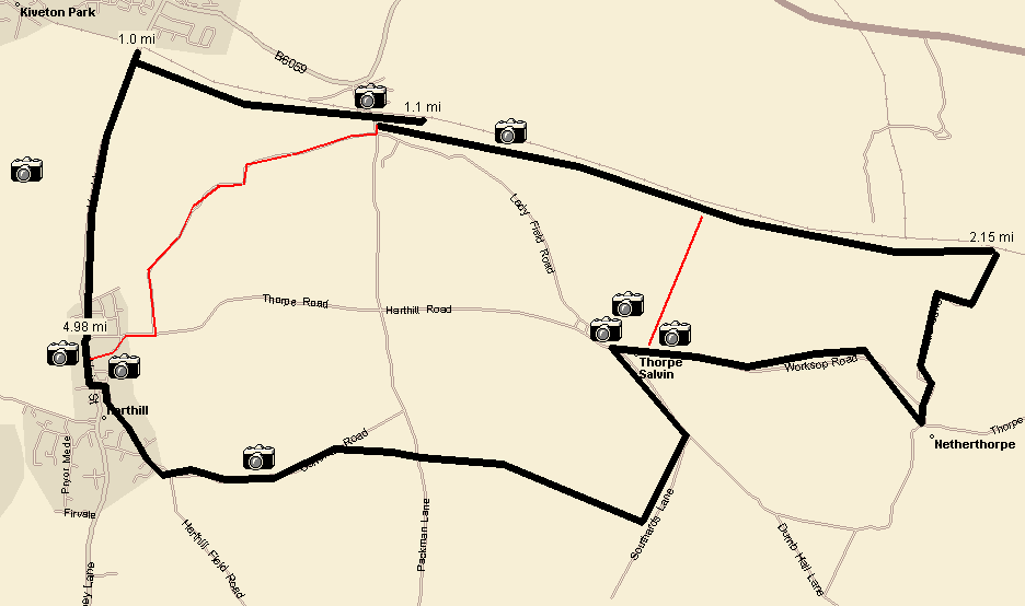
- From Kiveton Park Station car park head east along the canal
towpath past Hawks Wood. This walk is very pleasant, especially in
the summer when the sun's shining. See the Chesterfield Canal pages.
- NOTE: You can turn right over the third canal
footbridge to head straight into Thorpe (the straight red
line above) if you don't fancy the road walk from Turnerwood to
Thorpe. Alternatively you could just walk the canal towpath between
Kiveton Station and Turnerwood, with a detour to Thorpe's cultural
buildings (and pub) - in which case it's 90% off road, flat, and
about 5 miles long.
- 2 miles from Kiveton Station you get to Turnerwood, from which
you turner right and head towards the drone of light aircraft from
NetherThorpe/Sheffield Aero Club. See the Sheffield Aero Club entry.
- In Thorpe Salvin you can take in the ruins of the Elizabethan
manor house Thorpe Hall, and the
medieaval church (or go to the Parish
Oven pub). From Thorpe it's probably best to make the 2 mile trip
to Harthill cross country on footpaths, rather than trudging along
more country roads.
- Enter Harthill along Common Road, and go downhill down Serlby
Lane, and check out the fine old mediaval
church, burial place of generations of the Dukes of Leed's
(including the historically significant 1st Duke Thomas Osbourne).
- Then slog up the hill (Hard Lane) towards Kiveton and down the
other side, admiring the old colliery slag heap and other fine
views from the top, and down the other side. You can cut out this
hill by going around the back of Harthill Church, out of Harthill
along Thorpe Road and turn left down Manor Road, back to Kiveton
Station (the zigzag red line).
- At the bottom of the hill on the left is a solitary house (you
can't miss it, the barking dogs let you know its there).
- Walk past it 100 yards and crossing the road take the path
across Tommy Flockons. From the church to the right turn across
Tommy's is about 1 mile. From where you walk about another mile
across Tommy's and along the canal towpath, and back to the Old
Station pub/railway station carpark.
Use the Ordnance
Survey Pathfinder map number 744 - Aughton & Carlton in
Lindrick to stop you getting lost.
5. A 3 mile circular walk - Anston Stones
Its barely worth describing the walk in any detail as the place
is very self contained at 1.5 miles long by .75 mile wide. It runs
alongside the A57 just outside Anston crossroads heading towards
Worksop (along Worksop Road infact). There's a layby 1 mile east of
the crossroads where you can park. The entrance next to the layby
has a map and a potted description of the woods and stones on a
display board.
There's also a good walk in from Ryton Road (near the railway
bridge/school) in North Anston.
Footpaths only, no bikes, horses (or motor transport)
allowed.
6. A 14 mile '3 churches' walk - Laughton en len Morthen -
Tickhill
This one comes courtesy of the Rotherham Rambling club who's
site describes the route at Tickhill
Castle - Laughton Castle circular walk.
Want to comment on this page? Then visit the new
Web design, content, gfx by Techasaurus. Page content copyright Paul Newbold 2010.